Flood Alert System in Nepal: 7 Urgent Solutions That Could Save Thousands of Lives
Introduction: The Warning Should Reach People Before the Water Does
A river does not need permission to rise.
It does not wait for a government meeting, a television bulletin, a Facebook post, or a helicopter to arrive.
When water suddenly surges through a mountain valley, the difference between safety and tragedy can sometimes be measured in minutes.
That is why the conversation around floods in Nepal must move beyond what happens after disaster strikes.
We need to ask a more important question:
How quickly can life-saving information reach the person standing beside the river?
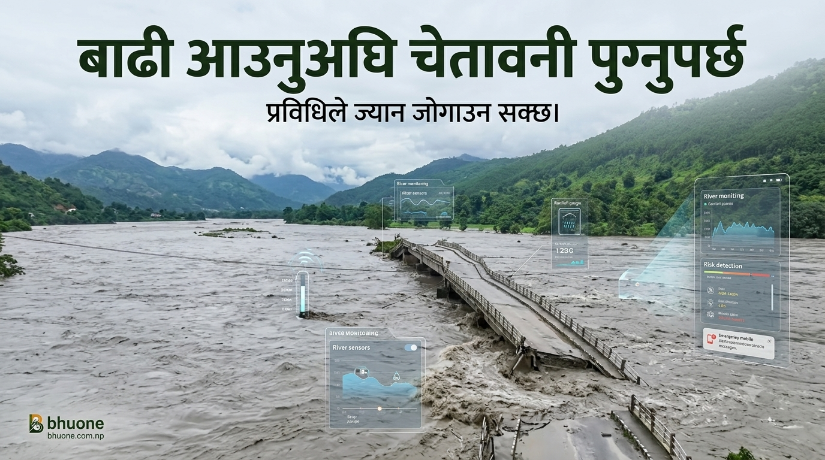
The devastating flash flood that struck the Bhote Koshi area of Rasuwa on August 26, 2026, has once again exposed this question. Reports say the sudden flood caused deaths, destroyed homes and infrastructure, damaged hydropower projects, and forced authorities to warn downstream communities to move to safer ground. Helicopters were dispatched for rescue, but high water made landing difficult in affected areas.
Live recent flood video
https://www.facebook.com/share/r/19K5s6jEFt/
The event has also triggered public discussion about early warning, official communication, downstream risk, cross-border information, telecommunications, river monitoring, and emergency response.
But there is an important fact we should recognize before criticizing the entire system.
Nepal already has pieces of a flood early-warning system.
The Department of Hydrology and Meteorology (DHM) monitors river conditions and operates flood forecasting and warning services. DHM’s flood-monitoring platform classifies rivers according to warning and danger levels, including whether water is rising or falling.
Ncell has also been working with DHM since 2016 to distribute location-based flood warning SMS messages. In 2026, Ncell reported sending more than 4.4 million flood early-warning alerts during the first two months of the monsoon period.
So the real question is not:
“Why doesn’t Nepal have a flood alert system?”
The better question is:
“How can Nepal turn its existing warning infrastructure into a faster, smarter, more universal life-saving network?”
That is where technology can meet nature.
And that is where Bhuone begins.
What Is a Flood Alert System in Nepal?
A Flood Alert System in Nepal is not simply an SMS saying that a river is rising.
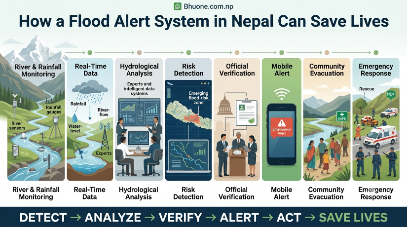
A truly effective system is a chain of connected actions:
Detect → Analyze → Predict → Verify → Alert → Evacuate → Respond → Update
The first stage begins with information.
River-level sensors, rainfall measurements, weather forecasts, satellite observations, hydrological models, and local observations can provide signals about changing conditions.
That information must then be analyzed to determine whether the situation is normal, potentially dangerous, or immediately life-threatening.
Once a warning threshold is reached, the message needs to move rapidly from the technical system to the public.
And this is where communication becomes just as important as prediction.
A perfect prediction that nobody receives is not an effective warning.
Likewise, a warning that reaches people but does not clearly explain where to go, when to leave, and what to avoid is incomplete.
A modern flood-warning system therefore has to be both technological and human.
Why Nepal Needs a Stronger Flood Early Warning System
Nepal’s geography makes flood preparedness particularly complicated.
The country rises rapidly from the plains into hills and high mountains. Rivers cross steep terrain, settlements exist along river corridors, roads follow valleys, and major infrastructure—including bridges and hydropower facilities—is often located close to water.
At the same time, Nepal faces monsoon rainfall, landslides, changing climate conditions and growing exposure of communities and infrastructure.
Nepal News recently described the country as highly exposed to multiple natural hazards, with thousands of disaster-related deaths recorded over recent decades.
But vulnerability does not mean helplessness.
It means our warning systems have to be designed around the reality of the landscape.
A warning for a village beside a river cannot be treated exactly like a warning for a city several hundred kilometers downstream.
The system needs to understand:
- Where the water is rising
- How quickly it is rising
- Which river system is affected
- Which communities are downstream
- How long the water may take to reach them
- Which roads and bridges may become unsafe
- Where people can evacuate
- Which emergency services are available
- Whether the warning has actually reached people
That is the difference between information and actionable intelligence.
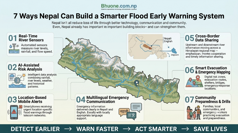
1. Build a Real-Time National Flood Intelligence Network
The first urgent improvement is simple:
Nepal needs to see rivers as they change—not only after they become dangerous.
DHM already operates hydrological monitoring infrastructure and provides flood forecasting services. Its monitoring system tracks river conditions relative to warning and danger levels.
The next step is to make this information increasingly connected.
Imagine a national flood intelligence dashboard where authorized agencies can see:
- River levels in real time
- Rate of water-level increase
- Rainfall intensity
- Upstream conditions
- Weather forecasts
- Satellite observations
- Flood-risk zones
- Roads and bridges
- Population exposure
- Critical infrastructure
- Evacuation centers
This does not mean replacing human decision-makers with artificial intelligence.
It means giving them better information.
A river rising 20 centimeters over several hours is different from a river rising 20 centimeters in a few minutes.
The rate of change matters.
AI and data analytics can help identify unusual patterns and prioritize areas requiring human attention.
Technology should not make the final decision blindly.
It should help people make that decision earlier.
2. Turn Every Mobile Phone Into a Potential Emergency Warning Device
This may be the most practical opportunity Nepal already has.
Ncell and DHM have demonstrated that location-based flood SMS alerts can reach people in flood-prone areas. Ncell says it has been distributing these warnings through its collaboration with DHM since 2016.
The company reported sending more than 4.4 million flood early-warning alerts in the first two months of 2026, while its wider disaster-warning collaboration has expanded to cover multiple hydrological and meteorological hazards.
This is powerful.
Because a warning system does not need every citizen to install an app.
It does not need everyone to follow a Facebook page.
It does not need everyone to have mobile data.
A simple message can reach a basic mobile phone.
But the next generation of emergency communication could go further.
Imagine receiving:
URGENT FLOOD WARNING
Your current area is at high risk. Move away from the river immediately. Avoid bridges and low-lying roads. Follow official evacuation instructions.
And imagine the message being available in:
Nepali + English + locally appropriate languages where necessary.
For tourists, migrant workers, and international visitors, English could be especially useful in major travel corridors.
The principle is simple:
A person should not need to search for a warning. The warning should find the person.
3. Move Beyond SMS: Create Multi-Channel Emergency Alerts
SMS is powerful, but one communication channel should never be the only line of defense.
A future-ready Flood Alert System in Nepal could combine:
SMS
For broad mobile reach.
Cell Broadcast
For location-based emergency messages that can reach compatible devices without depending on individual subscriptions in the same way as conventional messaging.
Mobile Applications
For people who want detailed information, maps and continuous updates.
Automatic Voice Calls
Useful for high-risk areas, elderly residents, people with limited literacy, or situations where an alert requires immediate attention.
Radio
Still essential during emergencies, especially when internet or electricity is disrupted.
Television
Useful for large-scale public warnings.
Sirens
Especially important in river corridors and communities with known evacuation routes.
Social Media
Useful for rapid public communication—but only when linked to verified official information.
Local Authorities and Community Networks
Technology cannot replace human relationships.
The strongest system uses all of them together.
4. Give People Location-Specific Warnings, Not Generic Fear
One of the concerns visible in public discussions after a major flood is confusion over which areas are actually at risk.
This is a serious issue.
An emergency message should answer:
Where?
When?
How dangerous?
What should I do?
Where should I go?
For example:
HIGH FLOOD RISK — MOVE TO HIGHER GROUND
River: Bhote Koshi
Area: [verified municipality/settlement]
Risk: Rapid water-level rise
Action: Leave riverbank areas immediately. Avoid bridges and low-lying roads. Follow local authority instructions.
That is much more useful than:
“Flood alert! Stay safe.”
A warning system should be designed around risk maps, not simply administrative boundaries.
A river does not care where one district ends and another begins.
Water follows terrain.
Therefore, warning models should understand watersheds, river networks and downstream travel.
5. Connect Upstream Information With Downstream Communities
This is one of the most important lessons from mountain flood events.
A community downstream may have clear skies while a dangerous event is developing upstream.
That means people cannot rely only on what they see above their own houses.
A flood-warning network should connect:
Upstream observation → Hydrological model → Downstream prediction → Local alert
This becomes especially important for rivers whose headwaters cross or approach international borders.
The August 2026 Bhote Koshi disaster has again raised questions about upstream conditions and cross-border information sharing. The exact cause of the current event should be established through proper hydrological investigation rather than speculation. Reuters reported that the cause remained unclear at the time of its report.
But Nepal has a broader reason to strengthen such cooperation.
In 2025, Nepal and China agreed to cooperate on glacial-lake flood risks and improve information sharing following earlier flood disasters in the region.
This is important because rivers do not stop at political borders.
Hydrological reality is bigger than national boundaries.
If an upstream event can affect downstream lives, information about that event can also become a form of humanitarian protection.
6. Use AI to Detect Unusual River Behavior
Artificial intelligence is often presented as something futuristic.
But disaster management provides a practical reason to use it.
AI could analyze combinations of:
- Rainfall
- River levels
- Historical patterns
- Temperature
- Snow and glacier conditions
- Satellite imagery
- Terrain
- Water-level velocity
- Weather forecasts
- Upstream observations
The goal would not be to tell people:
“AI says a flood will happen.”
That would be irresponsible.
Instead, AI could help authorities identify:
“This pattern is unusual and deserves immediate human review.”
That distinction matters.
AI should support experts—not replace them.
A human hydrologist understands context that an algorithm may not.
But an algorithm can process huge amounts of information continuously.
Together, they can potentially detect danger faster.
This is exactly the kind of technology Bhuone believes in:
technology that listens to nature instead of trying to dominate it.
7. Make Emergency Response as Intelligent as Early Warning
Early warning is only half of disaster preparedness.
The second half is response.
Suppose an alert reaches 100,000 people.
What happens next?
Where do they go?
Which roads remain safe?
Which bridges should be closed?
Where are ambulances?
Where are rescue teams?
Which hospitals have capacity?
Where are vulnerable people?
Which communities still need evacuation?
This is where live maps can become powerful.
Imagine an emergency command platform showing:
Red: Immediate danger
Orange: Evacuation preparation
Yellow: Monitoring
Green: Safe or normal conditions
Now add:
- Ambulance locations
- Police units
- Armed Police Force teams
- Army rescue teams
- Helicopter availability
- Road closures
- Bridge status
- Shelters
- Hospitals
- Communication outages
The result becomes more than a flood map.
It becomes a national emergency coordination system.
Helicopters Are for Rescue. Warning Systems Should Work Before Helicopters Are Needed.
There is nothing wrong with deploying helicopters during a disaster.
When people are trapped, helicopters can save lives.
But we should ask a harder question:
Why should our first technological response begin after people are already trapped?
A helicopter is an emergency response tool.
A sensor is an early-warning tool.
An SMS is an early-warning tool.
A river model is an early-warning tool.
A satellite is an observation tool.
A community evacuation plan is a preparedness tool.
The strongest disaster-management system combines all of them.
The goal is not to eliminate rescue.
The goal is to reduce the number of people who need rescue.
Why Official Information Matters as Much as Speed
During disasters, information itself can become dangerous.
A rumor spreads faster than a river in some cases.
One social media post can create panic.
Another can create false reassurance.
A third can incorrectly identify an affected district.
This is why emergency communication needs one trusted source of truth.
DHM has the technical role of monitoring and providing hydrological and meteorological information, while disaster-management authorities and local administrations have responsibilities for response and public safety.
The public should be able to recognize an official warning immediately.
A national emergency-alert format could include:
Government of Nepal
Verified Emergency Alert
Hazard
Location
Time
Risk Level
Required Action
Source
Emergency Contact
That small amount of structure could dramatically improve public understanding.
From Social Media Confusion to Verified Community Information
Social media has one enormous strength:
speed.
But speed without verification can create confusion.
The answer is not to silence people.
The answer is to create a system where verified information is easier to find than rumors.
A Bhuone vision for emergency communication would be:
Official data → verified alert → local authority → community → public feedback
Citizens should also be able to report:
- rising water
- blocked roads
- damaged bridges
- missing people
- landslides
- stranded families
But these reports should be treated as field observations, not automatically as verified facts.
Technology can help authorities compare citizen reports with sensor data and imagery.
This creates a two-way system.
The government informs citizens.
Citizens inform the system.
That is a more resilient society.
Nepal Already Has a Foundation. Now We Need to Connect It.
This is perhaps the most important conclusion from our research.
It would be inaccurate to say Nepal has done nothing.
DHM already operates flood monitoring and forecasting services.
Ncell already works with DHM to send location-based flood alerts through SMS.
Ncell also says its disaster preparedness includes measures for maintaining telecommunications during floods and landslides, including backup power and mobile emergency equipment.
So the foundation exists.
The opportunity is to connect and strengthen it.
Nepal could work toward a unified system that connects:
DHM
↓
River Sensors + Weather + Satellite Data
↓
AI-Assisted Risk Analysis
↓
National Emergency Operations
↓
Nepal Telecom + Ncell
↓
SMS + Cell Broadcast + Voice + Apps
↓
Local Governments
↓
Police + APF + Army + Health Services
↓
Communities
That is the network Nepal should be building.
What Could a Future Flood Alert in Nepal Look Like?
Imagine a warning at 8:05 AM.
A river sensor detects an abnormal rise.
At 8:06 AM, the system compares it with upstream rainfall, river velocity and historical patterns.
At 8:07 AM, the hydrological team verifies the signal.
At 8:08 AM, the system identifies downstream settlements at risk.
At 8:09 AM, emergency agencies are notified.
At 8:10 AM, location-based alerts begin reaching mobile phones.
At 8:11 AM, local governments activate evacuation plans.
At 8:12 AM, police and rescue teams move toward predetermined locations.
At 8:15 AM, roads and bridges in the projected danger corridor are reviewed.
At 8:20 AM, public communication channels broadcast the same verified message.
The river may still be hours—or perhaps only minutes—away.
But the community is no longer waiting blindly.
That is what early warning should mean.
What Citizens Can Do Today
Technology cannot protect people who ignore warnings.
Every family living near a river, stream, landslide-prone slope or other hazard zone should have a basic emergency plan.
Know your risk
Understand the nearest river, stream, slope and evacuation route.
Keep emergency contacts available
Save official emergency numbers before disaster happens.
Do not wait for the water to reach your house
If authorities issue an evacuation order, leave early.
Avoid bridges during rapidly rising floods
A bridge that looks safe can become dangerous quickly.
Keep phones charged
A mobile phone can become an emergency lifeline.
Keep important documents protected
Use waterproof storage where possible.
Prepare essential medicine and supplies
Emergency preparation is easier before panic begins.
Help vulnerable neighbors
Children, elderly people, people with disabilities and isolated households may need additional support.
Verify before sharing
Before forwarding a frightening flood message, ask:
Who published it?
Is it official?
Where is the evidence?
Does the information match the latest government warning?
During a disaster, responsible sharing is itself a form of public service.
What Government and Telecom Companies Can Do Next
Nepal does not necessarily need to invent everything from zero.
It can improve and integrate what already exists.
1. Expand location-based alerts
Make sure warnings reach every person in a defined risk zone as rapidly as possible.
2. Strengthen cross-border information sharing
Especially for rivers and hazards originating upstream of Nepal.
3. Improve local risk maps
People need warnings for the places where they actually live, work and travel.
4. Use multiple communication channels
SMS should be one layer—not the entire system.
5. Improve multilingual communication
Nepali and English can be complemented by locally appropriate languages where necessary.
6. Build public trust
Every warning should clearly identify its official source.
7. Test the system
An emergency system that has never been tested is only a theory.
Regular community drills could reveal problems before real floods do.
The Deeper Lesson: We Cannot Stop Every Flood
This is where the conversation needs maturity.
Technology cannot stop a glacier from changing.
It cannot stop every extreme rainfall event.
It cannot command a river to remain inside its old channel.
And it cannot guarantee that every disaster will be predicted perfectly.
But technology can help us understand risk earlier.
It can help us communicate faster.
It can help us coordinate better.
And it can help communities make safer decisions.
That is enough to save lives.
Bhuone Perspective: Technology Should Warn Us, Not Separate Us From Nature
At Bhuone, we often talk about the relationship between technology and nature.
We believe technology becomes meaningful when it serves life.
The same principle applies to disaster management.
A river is not our enemy.
A flood is not simply nature “attacking” us.
A river is part of an ecosystem.
The danger grows when human settlements, infrastructure, climate pressures and natural processes collide without sufficient preparation.
We should not respond to nature only after it becomes destructive.
We should learn to listen earlier.
Sensors can listen.
Satellites can listen.
Weather models can listen.
AI can listen.
But ultimately, people must listen.
Technology gives us information.
Wisdom determines what we do with it.
That is the future Bhuone believes Nepal can build:
a country where technology does not pull people further away from nature, but helps us understand nature better.
A Flood Warning Is More Than a Message
It is easy to think of an emergency SMS as just a few lines of text.
It is not.
Behind that message can be:
a sensor,
a river,
a weather model,
a hydrologist,
a telecom network,
a local government,
a rescue team,
a family,
and perhaps an entire community deciding whether to leave home.
One message can create minutes.
Minutes can create distance.
Distance can create safety.
And sometimes, safety is the difference between life and loss.
That is why Nepal should continue strengthening its Flood Alert System—not because technology can eliminate disasters, but because better information can reduce the human cost of disasters.
Conclusion: Nepal Should Prepare Before the River Rises
The lesson from Nepal’s recent floods should not be limited to grief.
There will be grief, and we must respect it.
There will be questions, and they deserve evidence-based investigation.
There will be accountability, and it must be pursued responsibly.
But there should also be learning.
Nepal already has important pieces of a national early-warning ecosystem. DHM monitors rivers and provides flood information, while partnerships with telecom operators such as Ncell have already demonstrated that mobile alerts can reach people in flood-prone areas.
Now we need to connect the pieces more intelligently.
Detect earlier.
Verify faster.
Predict better.
Alert everyone at risk.
Give clear instructions.
Coordinate the response.
Learn after every disaster.
The future of disaster management in Nepal should not be about choosing between nature and technology.
It should be about using technology to live more intelligently with nature.
Because we may never be able to stop every flood.
But we can work toward a Nepal where, when the river begins to rise, the warning reaches people before the water does.
And that is where technology can become more than innovation.
It can become a form of care.
Frequently Asked Questions
What is a Flood Alert System in Nepal?
A Flood Alert System in Nepal is a combination of river monitoring, weather forecasting, hydrological analysis, early-warning communication and emergency response designed to notify people about potential or developing flood risks.
Does Nepal already have a flood early-warning system?
Yes. Nepal’s Department of Hydrology and Meteorology operates flood monitoring and forecasting services, and works with other agencies and communication partners to distribute warnings.
Can people receive flood alerts by SMS in Nepal?
Yes. Ncell has an established collaboration with DHM to distribute location-based flood early-warning SMS alerts in vulnerable downstream areas.
What is DHM’s flood information number?
DHM currently lists 1155 as its toll-free number for extreme weather and flood information, with an option for flood early-warning information.
Can AI predict floods?
AI can help analyze large amounts of weather, river and environmental data and identify patterns or anomalies. However, AI should support qualified hydrological and disaster-management experts rather than replace them.
Why are mobile alerts important during floods?
Mobile alerts can reach people quickly in affected geographic areas and can provide direct instructions before conditions become more dangerous. They are particularly valuable because people do not necessarily need to be watching television or using social media when the warning is issued.
Should Nepal use automatic emergency phone calls?
Voice calls could be considered as an additional channel for particularly high-risk situations or vulnerable populations. Any such system should be carefully designed to avoid unnecessary alarm and protect telecommunications capacity during emergencies.
What should people do when they receive an official flood warning?
Follow the instructions immediately, move away from rivers and low-lying areas when advised, avoid unsafe bridges and roads, and follow evacuation instructions from verified authorities.
Useful Bhuone Reading
For a deeper understanding of how Bhuone approaches the relationship between technology, nature and sustainable systems, explore:
- Sustainable Farming in Nepal: 7 Powerful Reasons Technology Must Reconnect Humans with Nature
- AI-Driven Sustainable Farming in Nepal: 7 Smart Ways Technology Can Heal Nature